
Dew Point in a simple way
Just like that! With a lot more maps. graphics and info.

REMEMBER YOUR ROOTS

The dew point is the temperature where water vapor condenses into liquid water. Yay Wikipedia!

How much the amount of water vapor in the air affects human comfort? Identifying seasonal comfort levels makes sense when you are planing your yearly outdoor schedule and duties for that time period. Understand Dew Point and Relative Humidity levels are something to always keep in mind,. You could use condensation irrigation methods in your project. …

A 100-year flood happened last year so it won’t happen for another 99 years, right? Not exactly. Misinterpretation of terminology often leads to confusion about flood recurrence intervals. This history based info will assist you from acquiring the knowledge, to observing current rain events and predictions.observing the

This makes everything bigger! Can you imagine that you could build a sustainable system and end up feeding the aquifer near you? Not just you can use the natural water that comes from rain and bodies of water, but you can also take into consideration your irrigation practices and cooperate for water conservation. Here you …
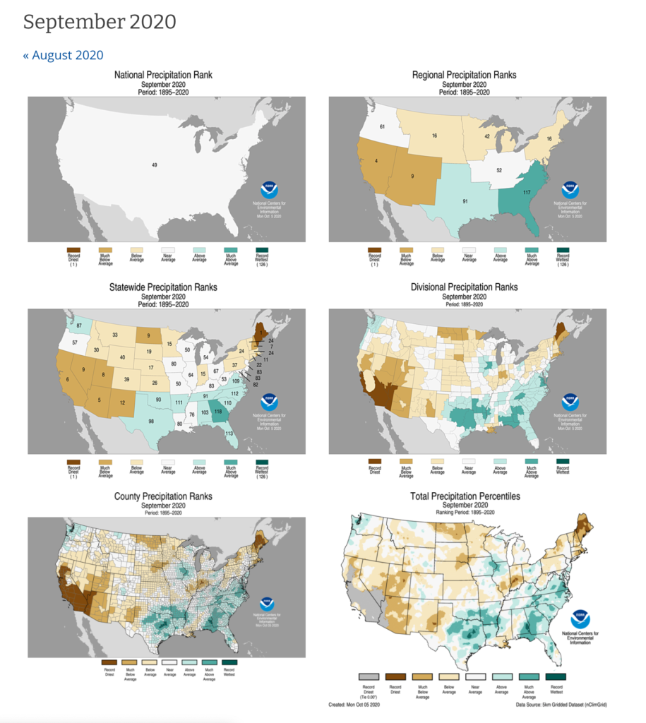
Nooa provides you such good and accurate information about climate thats it’s incredible! Take a look at the US Precipitation Maps. When it comes to symbiotic relationships in the globe, you have to keep in mind that the world is much bigger than just your property. Maybe start from your neighbors 🙂

With no water, there is no life! Great slogan right? Wouldn’t be cool if you could gather all the water information around you and identify the different kinds of water sources you have available (city, rain, pond, etc…)? Im sure tis website will bring you knowledge and clarification. Go get a water tester and start …

Another very needed map you find here. It will keep you on your toes when being smart to utilize each area according to the amount of water you have, or could have in case of a flood event. A Flood Map will help to do the job, right?

This website gives you a very detailed description of Ecoregion Sites, and much more! Water, soil, dynamics, references……so much information that adds up when identifying the soil type, and with a full Ecological Site Definition!

With the Agroforest Project Initiated, we came across many amazing links and resources after the Permaculture Design Course. We wanted to understand the soil formation history and geology around us to connect with the land in a different way. The history of your property will provide you with very valuable information that will help you …